Bedford–Stuyvesant, Brooklyn
Bedford–Stuyvesant | |
|---|---|
Neighborhood of Brooklyn | |
 | |
| Nicknames: Bed-Stuy, Do or Die | |
Location in New York City | |
| Coordinates: 40°41′13″N 73°56′28″W / 40.687°N 73.941°W | |
| Country |  United States |
| State |  New York |
| City |  New York City |
| Borough |  Brooklyn |
| Community District | Brooklyn 3[1] |
| Area | |
| • Total | 7 km2 (2.8 sq mi) |
| Population (2022)[2] | |
| • Total | 166,380 |
| • Density | 23,000/km2 (59,000/sq mi) |
| Ethnicity | |
| • Black | 41.2% |
| • White | 29.3% |
| • Hispanic | 17.8% |
| • Asian | 4.2% |
| • Others | 7.5% |
| Economics | |
| • Median income | $71,123 |
| Time zone | UTC−5 (Eastern) |
| • Summer (DST) | UTC−4 (EDT) |
| ZIP Codes | 11205, 11206, 11216, 11221, 11233, 11238 |
| Area code | 718, 347, 929, and 917 |
Bedford–Stuyvesant (/ˌbɛdfərd ˈstaɪvəsənt/ BED-fərd STY-və-sənt), also known as Bed–Stuy,[3] is a neighborhood in the northern section of the New York City borough of Brooklyn.
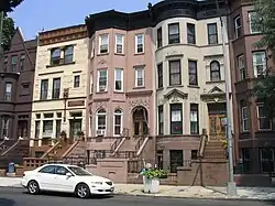
Bedford–Stuyvesant has the largest collection Victorian architecture in the United States, with roughly 8,800 buildings built before 1900.[4]
References
- ↑ "NYC Planning | Community Profiles". communityprofiles.planning.nyc.gov. New York City Department of City Planning. Retrieved March 18, 2019.
- 1 2 "Census profile: NYC-Brooklyn Community District 3--Bedford–Stuyvesant PUMA, NY". Census Reporter. Retrieved 2024-09-13.
- ↑ Woodsworth, Michael (May 6, 2016). Battle for Bed–Stuy: The Long War on Poverty in New York City (illustrated ed.). Harvard University Press. ISBN 9780674545069.
- ↑ Gregor, Alison (July 9, 2014). "Bedford-Stuyvesant: Diverse and Changing". The New York Times. ISSN 0362-4331. Retrieved July 16, 2019.