Ōkuma, Fukushima
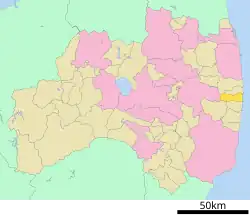


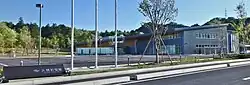
Ōkuma (大熊町, Ōkuma-machi) is a Japanese town in Fukushima Prefecture on the island of Honshu.
The latitude is 37°22'19" ~ 37°25'50" N and the longitude is 140°51'29" ~ 141°2'30" E.
In 2003, the estimated population was 10,945, with a population density of 139.07 inhabitants per km². The total area is 78.70 km².
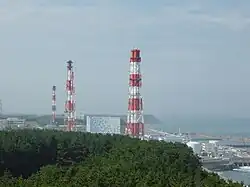
The Fukushima Nuclear Power Plant No. 1 is located in the city where a series of nuclear accidents occurred in 2011.
As of May 1, 2023, the city had 10,004 inhabitants in 4,852 households. However, this figure is significantly higher than the actual number, as the municipality continues to keep records of residents despite evacuations to settlements elsewhere in the country. The city's actual population was 545 in May 2023 and 1,052 as of August 4, 2025.
Geography
There are three towns, one village, one city, and one district next to Ōkuma.
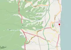
Ōkuma is located on the Pacific Ocean coast, in the central part of Fukushima. Ōkuma is located in the center of the Hamadōri region of Fukushima, bordering the Abukuma Highlands to the west and the Pacific Ocean to the east. It lies between the cities of Namie and Futaba to the north, Tamura to the west, and Kawauchi and Tomioka to the south. The city is home to the Fukushima Daiichi Nuclear Power Plant.
Within the city limits is Mount Higakure (日隠山, Higakure-yama), with an elevation of 601.5 m above sea level. The Kuma River (熊川, Kuma-gawa) also flows through the city.
The city is bordered to the east by the Pacific Ocean, to the west by the city of Miyakoji in Tamura Ward near the Abukuma Mountains, to the south by the cities of Tomioka and Kawauchi, and to the north by Namie and Futaba.
Tren is high in the west and low in the east, with an altitude ranging from 695 to 3 m above sea level. It covers an area of 15.4 km from east to west and 6.7 km from north to south. Mountains and forests cover 65% of the total area, of which approximately 50% is state-owned.
The Abukuma Mountains extend toward the sea from three hills, to the south, center, and north of the city, respectively. Three rivers flow between them: the Kuma, Koirino, and Ottozawa to the east, with farmland in their basins.
The terrain of Ōkuma Machi is mountainous in the west but flat in the east.
The climate is oceanic, annual precipitation is about 1,200 mm, and there is almost no snow, even in winter.
North: Sōma (48 km), Sendai (104 km) South: Iwaki (47 km), Mito (142 km). West: Kōriyama (77 km), Aizuwakamatsu (137 km)
Surrounding municipalities
- Fukushima
- Futaba
- Kawauchi
- Nami
- Tamura
- Tomioka
Demographics
According to Japanese census data, Ōkuma's population grew steadily over the past 40 years until the nuclear disaster.
- | 1920 | 5,790
- | 1930 | 6,401 (+10.6%)
- | 1940 | 6,044 (−5.6%)
- | 1950 | 8,760 (+44.9%)
- | 1960 | 8,206 (−6.3%)
- | 1970 | 7,750 (−5.6%)
- | 1980 | 9,396 (+21.2%)
- | 1990 | 10,304 (+9.7%)
- | 2000 | 10,803 (+4.8%)
- | 2010 | 11,515 (+6.6%)
- | 2018 | 10,402 (−9.7%)
- | 2020 | 10,265 (−1.3%)
- | 2023 | 10,004 (−2.5%)
History
From its name "Kuma" to the present day, Okuma has historically been a border area where northern and southern powers competed. Historically, Okuma is known as the northern gateway to the Kantō-Tohoku border area.
"Kuma"
During the Kuni no Miyatsuko period in the first half of the 7th century, present-day Okuma formed the northern boundary of Iwaki Kuni no Miyatsuko and the northern boundary of Taka Province and was called "Kuma Village". Furthermore, while Sukegawa (present-day Hitachi City in Ibaraki Prefecture) was called "Michinokuchi no Kihe", Kuma Village was called "Michinoshiri no Kihe". Taka Province was a regional state formed by the merger of the three regions of Taka Kuni no Miyatsuko, Kikuta no Miyatsuko, and Iwaki Kuni no Miyatsuko. This region has a geographical and historical identity, as in the first half of the 20th century it became an energy source region, along with the Hitachi mines and the Joban coal mines.
With the establishment of the Ritsuryō system in the second half of the 7th century, Taka Province was incorporated into Hitachi Province, with Kuma Village as its northern boundary. However, in 718, in the early Nara period, the area north of Kikuta County, whose boundary is at present-day Nakoso (Hiragata Tunnel), was separated from Hitachi Province and incorporated into Sekishiro Province, which extended from Nakoso to Watari, with Kuma Village becoming the central village of Sekishiro Province. However, around 728, Sekishiro Province was incorporated into Mutsu Province.
"Kumakawa"
The village of Kuma, in the 7th century, was renamed Kumakawa, after the river that flows through the area, and this period lasted until the end of the Boshin War.
From the founding of the Kamakura shogunate until the first half of the Sengoku period, Kumakawa became the territory of the Shireha clan and formed the southern border of their territory.
However, in the second half of the Sengoku period, the Shireha clan was defeated by the Sōma clan. The Sōma clan's dominance lasted from the second half of the Sengoku period until the end of the Boshin War, and Kumakawa became the southern border of the Sōma clan's territory. The border between the Sōma and Iwaki clans during the Sengoku period, as well as the border between the Sōma-Nakamura and Iwaki-daira domains during the Edo period, was the town of Yonomori, located on the present-day border between the cities of Okuma and Tomioka. At the end of the Sengoku period, Kumakawa served as a buffer zone between the Sōma, Iwaki, and Tamura clans. When the Tamura Territory became a vassal domain of Date Masamune, who continued his expansion in defiance of Toyotomi Hideyoshi, the Sōma clan, along with the Iwaki clan, moved west from Kumakawa to invade the Tamura Territory. This route is now known as National Highway 288.
During the Edo period, during the Tokugawa shogunate, Kumagawa came under the control of the Nakamura dynasty, and a post town was established on Hama-kaido (now National Highway 6) and flourished as a post town called Kumagawa-juku.
"Okuma"
On September 22, 1868, Soma Nakamura Domain was defeated by Meiji government forces in the Boshin War. As a result, the former territory of Nakamura Domain, including Kumagawa, was transferred to Iwaki Prefecture. Following the abolition of feudal domains and the creation of prefectures on August 29, 1871, Kumagawa initially belonged to Nakamura Prefecture, but on January 9, 1872, Nakamura Prefecture and Taira Prefecture (formerly Iwaki Taira Domain) were merged to form Iwasaki Prefecture. On August 21, 1876, Iwasaki Prefecture was merged with Fukushima Prefecture (Nakadori) and Wakamatsu Prefecture (Aizu) and has been part of Fukushima Prefecture ever since.
April 1, 1889: With the introduction of the town-village system, the villages of Ono and Kumamachi were established in Shioba County. April 1, 1896: Shioba and Naraha counties were merged to form Futaba County. November 22, 1904: Ono Station opened on the Joban Line. November 1, 1954: The towns of Oono and Kumamachi were merged to form the city of Okuma.
As a result of rapid economic growth, the mining region stretching from Sukegawa (Hitachi City) to Yonomori (the Hitachi Mine and the Joban Coalfields of the early 20th century) declined. Oil and nuclear power began to replace coal as new energy sources.
The Fukushima Daiichi Nuclear Power Plant was built in Okuma.[1]
Construction of the Fukushima Daiichi Nuclear Power Plant, owned by the Tokyo Electric Power Company, began in Okuma on September 29, 1967 (inauguration on March 26, 1971).
Two days later, on October 1, 1967, the entire Joban Line was electrified, completing electrification between Taira Station (present-day Iwaki Station) and Iwanuma Station. Okuma thus became the northernmost "energy zone." Residents of the Yonomori region, including Okuma and Namie, who had previously moved to other areas for winter work when agriculture was unavailable, were now able to work year-round at the nuclear power plants. Nuclear power plants were considered "lucky gods" for residents, providing stable employment and significant subsidies.
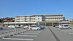
Following the opening of the Fukushima Daiichi Nuclear Power Plant and the end of a period of rapid economic growth, "nuclear monaki" (a type of bean jam sandwich) bearing the image of the Fukushima Daiichi Nuclear Power Plant were sold as souvenirs in Okuma. In 2006, the Ohno Hospital Incident symbolized the shortage of medical care and the problem of depopulation.
The area was evacuated because of the Fukushima nuclear disaster in 2011.[2]
On March 11, 2011, the Great East Japan Earthquake struck Okuma, causing damage measuring over 6.0 on the Richter scale. The earthquake triggered a hydrogen explosion at Unit 1 of the Fukushima Daiichi Nuclear Power Plant at 3:36 p.m. on March 12. To avoid radiation exposure, residents were forced to evacuate beginning on March 13, with many moving to the Tamura Municipal Gymnasium in Funabiki, Funabiki-cho, Tamura City, Fukushima Prefecture, where a temporary town hall was set up. (Other evacuees and evacuation sites were also dispersed.) On March 14, at 11:01 a.m., a hydrogen explosion also occurred at Unit 3 of the Fukushima Daiichi Nuclear Power Plant.
After April 3, the temporary city hall and evacuated residents were relocated to the Aizuwakamatsu City Hall's Oitemachi Second Building in Sakaemachi, Aizuwakamatsu City, Fukushima Prefecture. On April 5, a branch office of the Aizuwakamatsu Municipal Office (jointly with the Okuma Welfare Board and the Okuma Chamber of Commerce and Industry) opened at the new location. In mid-April, an elementary school, a junior high school, and a kindergarten opened in Aizuwakamatsu. (The elementary school and kindergarten were branches of Okuma Elementary School and Okuma Kindergarten, which were formed by merging existing local schools and kindergartens, and the junior high school was a branch of an existing school.)
Following the nuclear power plant accident, the town hall and residents were evacuated to nearby areas. From April 22, 2011, to December 9, 2012, the area was designated as a restricted access zone, with entry prohibited to all residents except workers performing decontamination, debris removal, and repair work. At midnight on December 10, 2012, the area was transformed into a "no return zone" (where entry and temporary return of residents other than workers is, as before, prohibited; however, temporary return (without overnight stays) may be permitted during the day, on designated days or by appointment; this corresponds to the former residence of 96% of the total population), a "restricted stay zone" and an "evacuation preparation zone" (where temporary entry and return during the day are only permitted with the authorization of the city council, but overnight stays are not permitted; in total, this corresponds to the former residence of 4% of the total population). The evacuation orders for the "restricted stay zone" and the "evacuation preparation zone" were lifted at midnight on April 10, 2019. The evacuation order for the "difficult return zone" around Ono Station was also lifted at midnight on March 5, 2020. At 9:00 a.m. on March 8, 2021, additional areas were opened to the public, and on November 30, 2021, the entire "Designated Base Area for Recovery and Revitalization" was opened to the public at 9:00 a.m. On June 30, 2022, the evacuation order for the entire "Designated Base Recovery and Revitalization Area" was lifted.
According to the New York Times in 2013, the people of Ōkuma, like many other communities in Fukushima, are "starting to come to terms with a sobering realization: their old homes are probably lost forever, and they must start anew elsewhere."[3]
The people who used to live in Ōkuma are called "nuclear refugees".[4]
Between 2013 and 2019, six men in their 60s, working as temporary municipal employees, formed the so-called "Elderly Squad" and patrolled the city from the local government liaison office near the Sakashita Dam in the western part of the city.
The Fukushima Daiichi nuclear power plant is currently being decommissioned.
Following the nuclear disaster, the city is striving to transform itself into a city powered by renewable energy sources. On January 18, 2024, a decarbonization collaboration agreement was signed, involving the transmission of electricity generated from solar energy and other sources to Tokyo's Chuo Ward and the absorption of carbon dioxide in local forests.
In 2024, the company signed a reconstruction cooperation agreement with the Ritsumeikan Trust, which manages Ritsumeikan University and other institutions.
Climate
Ōkuma has a humid subtropical climate (Köppen climate classification Cfa). The average annual temperature in Ōkuma is 12.1°C (53.8°F). The average annual rainfall is 1,329 mm (52.3 in), with September being the wettest month. The highest temperature is reached in August, at around 24.1°C (75.4°F), and the lowest in January, at around 1.5°C (34.7°F).
Education
Ōkuma has three public elementary schools, one municipal public junior high school, and one public high school operated by the Fukushima Prefectural Board of Education. Classes at all schools remain indefinitely suspended.
Due to the evacuation to Aizu-Wakamatsu, a new elementary and junior high school was opened there for Ōkuma children.
Gallery
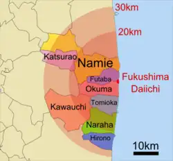 Fukushima disaster evacuation zones
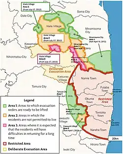 As of June 15, 2012: In addition to the restricted zone and the deliberate evacuation zone, there are three categories: Category 1: Area ready for lifting of evacuation order Category 2 = Residents are prohibited from permanent settlement Category 3 = Unsuitable for long-term return of residents
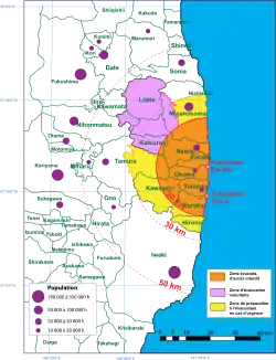 As of April 22, 2011: Orange = Restricted area within a 20 km radius Yellow = “Area prepared for evacuation” Pink = “Deliberate evacuation area”
- Evacuation Zones (2011)
Administration
[[File:Okuma town office.jpg|thumb|Former Town Hall. Following the nuclear disaster, the mayor's office was temporarily relocated to the Okuma City Hall headquarters in Aizuwakamatsu Ward. Mayor: Jun Yoshida (appointed November 20, 2019, second term)
- Shigeru Obata (December 3, 1954 - December 2, 1962)
- Hidemasa Shiga (December 3, 1962 - August 6, 1979)
- Endo Tadashi (September 25, 1979 - September 1987)
- Hideo Shiga (September 20, 1987 - September 19, 2007) Son of Hidemasa Shiga
- Toshitsuna Watanabe (September 20, 2007 - November 20, 2019)
- Jun Yoshida (November 20, 2019 - present)
Transportation
 JR East – Jōban Line
- Ōno
Highway
- Jōban-Ōkuma Expressway Interchange
- Route 6
- Route 288
Twin Cities
 Bathurst, Australia (Since March 1991)
Related pages
Sister city
A sister city relationship was established with Bathurst, New South Wales in Australia.[5]
References
- ↑ Yasushi Kaneko, "2 towns at risk of disappearing; Okuma, Futaba face uncertain future due to nearby crippled N-plant," Archived 2012-01-18 at the Wayback MachineYomiuri Shimbun, 9 Jan 2012; 2013-3-12.
- ↑ "Analysis: A month on, Japan nuclear crisis still scarring," International Business Times (Australia). 9 April 2011; excerpt, "The inability of Japanese authorities to regain full control of the plant will make villages nearby uninhabitable for a long time ..."; Archived 18 April 2011 at WebCite
- ↑ Tabuchi, Hiroko. "Uprooted by Tsunami, Church's Flock Regroups". New York Times. 11 March, 2013; retrieved 2013-3-12.
- ↑ "'Nuclear refugees' visit their home near stricken Fukushima plant," NBC News. 7 March 2013; retrieved 2013-3-12.
- ↑ "Sister City" Archived 2012-02-26 at the Wayback Machine, Bathhurst Regional council
Other websites
 Media related to Okuma, Fukushima at Wikimedia Commons
37°24′16″N 140°59′1″E / 37.40444°N 140.98361°E
| Cities | Aizuwakamatsu | Date | Fukushima (capital) | Iwaki | Kitakata | Kōriyama | Minamisōma | Motomiya | Nihonmatsu | Shirakawa | Sōma | Sukagawa | Tamura |  |
|---|---|---|
| Districts | Adachi | Date | Futaba | Higashishirakawa | Ishikawa | Iwase | Kawanuma | Minamiaizu | Nishishirakawa | Ōnuma | Sōma | Tamura | Yama | |
See also: Towns and villages by district | ||
